
Category:Maps
publication type or genre, visual representation of a concept space _ESA23162625.png) 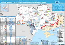 | |||||
| Upload media | |||||
| Pronunciation audio | |||||
|---|---|---|---|---|---|
| Instance of | |||||
| Subclass of |
| ||||
| Part of |
| ||||
| Different from | |||||
| |||||
Before changing or adding maps, please read the brief guideline on the organizational schema About this Category developed during an eight month effort by a working group in 2007–2008.
- See also maps needing categories in Category:Unidentified maps
- See also these related categories: (These categories may contain more maps. Please categorize them in map categories.)
- Category:Cartography – for map symbols, projections, etc.
- Category:Demography
- Category:Geography
- Category:Aerial photographs
- Category:Satellite pictures
- Category:Astronomical maps – maps and star charts
- Category:Cartographic reliefs for models of landscape profiles
Resources:
Subcategories
This category has the following 31 subcategories, out of 31 total.
!
*
+
?
A
C
- Catalogs of maps (1 F)
G
M
- Map worksheets (8 F)
P
T
- Mapping (text) (2 F)
- Maps with transparent background (108 F)
W
Pages in category "Maps"
The following 9 pages are in this category, out of 9 total.
Media in category "Maps"
The following 51 files are in this category, out of 51 total.
-
 1917 Map of the Country Club District.jpg 6,578 × 7,054; 7.75 MB
-
 2011 Ethnic Map at Settlement Level.png 1,920 × 935; 935 KB
-
 2019년 65세 이상 노인 비율.png 1,752 × 786; 297 KB
-
 Al Ahuaz Map Flag.png 830 × 542; 33 KB
-
 Antigua-barbuda-map-krc.jpg 740 × 740; 173 KB
-
 Arkoma Basin Map.jpg 1,042 × 1,042; 223 KB
-
 Bakis preview.png 700 × 492; 87 KB
-
 Blank Map of Africa With Borders and Without Dotted Lines.png 694 × 645; 10 KB
-
 Blank Map of The World Miller Cylindrical Projection.png 6,448 × 3,400; 308 KB
-
 Blank Map of The World Small Scale Mercator Projection.png 1,859 × 1,422; 40 KB
-
 Blank Map of Unified China People Republic of China.png 977 × 822; 7 KB
-
 Blank Map of United States Small Scale.png 597 × 481; 3 KB
-
 BPU Map fin.jpg 2,362 × 1,772; 805 KB
-
 Bulgarian map Simeon the Great.jpg 510 × 700; 71 KB
-
 Bushehr Map Lang.webp 480 × 596; 19 KB
-
 Bythaelurus bachi distmap.jpg 1,357 × 628; 78 KB
-
 Distribution map of known Tethya meloni occurrence.jpg 3,022 × 1,600; 306 KB
-
 Distribution map of Pachystegia minor.png 1,277 × 549; 53 KB
-
 Distribution map of Triglochin barrelieri.png 1,352 × 532; 151 KB
-
 Etmopterus lailae distmap.jpg 1,357 × 628; 79 KB
-
 Fibercities.png 877 × 574; 96 KB
-
 Gerichtsbezirk Salzburg-2023.svg 1,052 × 744; 30 KB
-
 Gerichtsbezirk Seekirchen.svg 1,052 × 744; 30 KB
-
 Grand-Remous Quebec location diagram.png 329 × 290; 17 KB
-
 Iwo Jima Bathymetric Chart by Japan Coast Guard.jpg 784 × 477; 221 KB
-
 Kampung Tanjong Bunut Map by Storymalting.png 2,560 × 1,440; 593 KB
-
 KF Canada-map-locations 2023-24.png 3,334 × 2,500; 245 KB
-
 Linguistic map of the Italian language world.png 1,918 × 819; 207 KB
-
 Listuguj Quebec location diagram.png 1,056 × 790; 169 KB
-
 LOPEZ MAP FINAL2 copy.png 7,072 × 5,000; 3.08 MB
-
 Mannangadinni village map.jpg 1,167 × 1,077; 99 KB
-
 Maps and Charts - All States - DPLA - 18abea1416172f763eeb3216e86b143a.jpg 4,192 × 3,403; 1.65 MB
-
 Maps and Charts - All States - DPLA - 697c1b0079515b653bb121f734b07a31.jpg 4,164 × 3,355; 1.57 MB
-
 Maps and Charts - All States - DPLA - ac1271d597ac251fc2752dc132861e74.jpg 4,238 × 3,437; 1.41 MB
-
 Maps and Charts - All States - DPLA - b4e5a9f12822496addcae05c367f3574.jpg 4,854 × 3,774; 1.45 MB
-
 Maps and Charts - All States - DPLA - f97c83b9413631958373b4260d9a1b29.jpg 4,242 × 3,391; 1.28 MB
-
 Mosaics map outlines.png 9,933 × 7,016; 49.56 MB
-
 NRHP base map proposed.svg 1,250 × 625; 1.2 MB
-
 Pakhli sarkar.gif 715 × 644; 143 KB
-
 Piloto Pardo Islands Map 2024-12-25.png 1,164 × 680; 260 KB
-
 Pimlico map 1810.png 2,268 × 1,504; 4.97 MB
-
 Political Boundary Map.jpg 810 × 535; 57 KB
-
 Qena Subdivisions.jpg 821 × 505; 101 KB
-
 Road Map of Pattani.png 701 × 437; 244 KB
-
 Rosd Map in Yala.png 512 × 598; 216 KB
-
 Sumy Povit map with volost subdivisions.jpg 4,406 × 3,544; 3.47 MB
-
 Tarail Emon.jpg 1,075 × 640; 167 KB
-
 The Assyrians.jpg 720 × 598; 131 KB
-
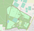 Wildpark an den Eichen-Map 1.svg 1,610 × 1,485; 1.6 MB
-
.png/120px-Знімок_екрана_(5).png) Знімок екрана (5).png 568 × 464; 34 KB
Знімок екрана (5).png 568 × 464; 34 KB
-
 قلمرو امپراتوری عثمانی در زمان محمد فاتح.png 2,000 × 1,218; 346 KB


.png)
